U.S.
Federal flood maps underestimated risk in areas hit hardest by Hurricane Helene
By
The Washington Post October 13, 2024
Kevin Crowe, Shannon Osaka and John Muyskens
The Washington Post October 13, 2024
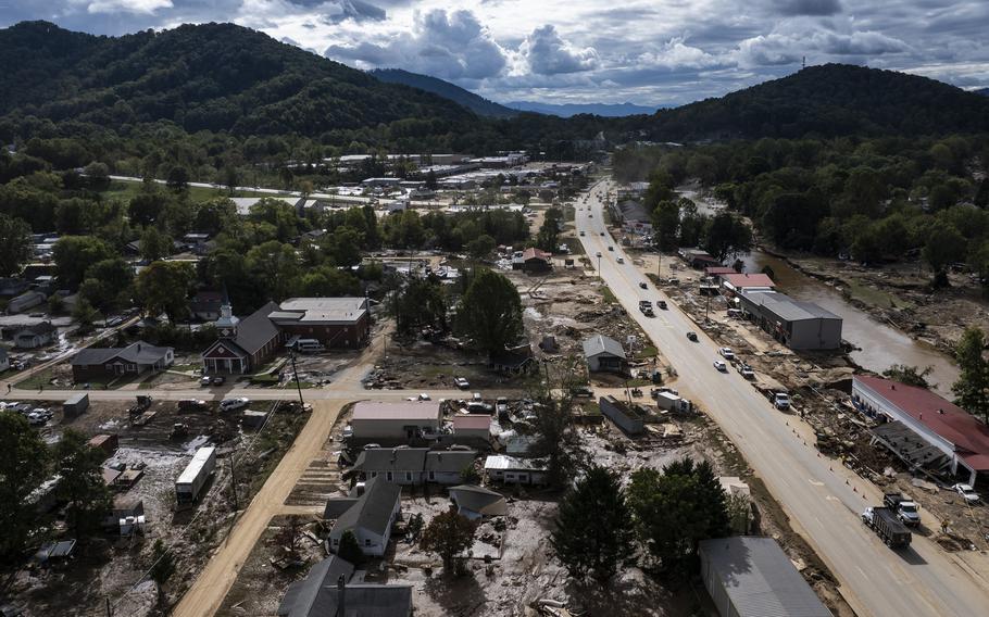
The Federal Emergency Management Agency did not designate this neighborhood in Swannanoa, N.C., a flood hazard zone. (Jabin Botsford/The Washington Post)
The federal government’s flood maps, which are used nationwide to signal areas vulnerable to inundation, vastly underestimated the flood risk faced by properties in the parts of North Carolina devastated by Hurricane Helene, according to data analyzed by The Washington Post.
The analysis of flood risk data from First Street, a climate modeling group, found that just 2 percent of properties in the mountainous counties of western North Carolina fall inside areas marked as having a special risk of flooding. That “Special Flood Hazard Area” designation, which compels homeowners to buy flood insurance if they want to get a federally-backed mortgage, indicates where the Federal Emergency Management Agency sees a risk of a 1-in-100-year flood. Scientists consider that zone, which amounts to a 1% chance of flooding in a given year, as facing significant danger.
In those mountainous areas, according to a Post analysis of First Street’s data, the number of properties at risk could be seven times higher than what FEMA flood maps indicate.
The discrepancy shows how the agency’s maps — which rely only on floods observed in the past and don’t take into account flooding from heavy rain, small streams and tributaries, or climate change’s future impact — can fall short when assessing current risks in a wetter, hotter world.
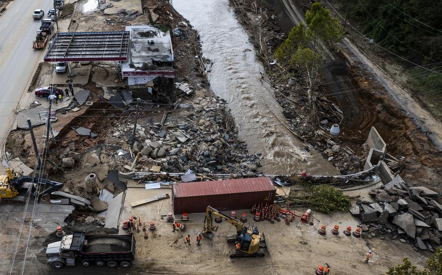
Hurricane Helene devastated the Appalachians late last month, dropping huge amounts of rainfall on mountain towns many thought were safe from extreme weather. The torrential precipitation obliterated roads, cut off communication systems, and left homes far from coastal areas flooded and destroyed.
In Buncombe County, where rising waters swamped areas like Asheville and Swannanoa, First Street’s maps show a much larger area of flood risk than the FEMA maps. About 2,100 properties out of about 125,000 in the county are in FEMA’s flood zone compared with 19,500 under First Street’s model, according to The Post’s analysis.
Flood experts say the maps need to be urgently updated to inform homeowners and prospective residents of their actual risk.
“We are now in an environment of constantly escalating risk,” said Carolyn Kousky, a flood insurance expert and the associate vice president for economics and policy at the Environmental Defense Fund. “And the maps aren’t keeping up.”
The Federal Emergency Management Agency did not designate this neighborhood in Swannanoa, N.C., a flood hazard zone. (Jabin Botsford/The Washington Post)
Former FEMA leaders and current agency officials, however, counter that the maps are not intended to be a full accounting of flood risk. Unlike First Street, a research and consulting group that offers climate-based risk assessments to companies and governments, FEMA is charged with mapping and regulating flood zones for the public.
First Street’s model — which incorporates flooding from heavy rain as well as from small streams and tributaries — finds roughly twice as many U.S. properties are at risk of a 1-in-100-year flood compared with those that fall inside a FEMA flood zone.
Many residents who suffered heavy flooding damage from Helene, including in Buncombe and Henderson counties in North Carolina, did not have coverage under the National Flood Insurance Program for those damages, according to an earlier Post analysis of FEMA data. The agency had just 949 active policies in Buncombe County when the storm hit.
Many areas of western North Carolina affected by flooding had FEMA flood maps that were 12 to 15 years old, according to Anna Weber, a senior policy analyst at the Natural Resources Defense Council. The maps covering Asheville were last updated in 2010, according to FEMA data. The agency says it evaluates the maps every five years and does not update them if the data still meets the standards of the program.
The amount of rainfall Helene brought to North Carolina was rarer than a 1-in-100-year event — meaning its full devastation might not have been captured by either model. But experts say that the larger the flood zone, the more residents may have been insured against the catastrophic damage the storm caused.
Blake Smith, whose home is in Bat Cave, N.C., in Henderson County, barely escaped with his life when a wall of water and mud came crashing down around him in his river cabin last month. The 51-year-old found his home demolished — entire walls ripped out, struts teetering over the rushing river below. His truck was crushed.
Smith had never heard of the National Flood Insurance Program. His cabin was 120 years old. “Everything is just gone,” he said.
The Post could not immediately confirm whether Smith’s home, which is on the edge of the federally designated Special Flood Hazard Area, was entirely in the zone.
Experts have long warned that FEMA’s flood maps may be lagging behind the current science of flood risk. They do not take into account flooding caused by heavy precipitation — which is expected to grow more intense as the Earth warms — and look only at past flooding conditions, rather than future climate risk.
“It’s like you’re driving down the highway but you’re only looking in the rearview mirror,” Weber said.
In Rutherford County, home to Chimney Rock and Lake Lure, around 9 percent of properties have a high risk of flooding under First Street’s model compared with 1 percent that are in the federal flood zone.
Former and current agency officials say that regulations dictate what the flood maps take into account and aren’t intended to encapsulate all flood risks across the nation.
Luis Rodriguez, FEMA’s engineering and modeling division director, said on a call with reporters Friday that developing the maps is a “collaborative effort” that involves consultation with state and local officials.
“It takes a long time to go through the process that is required under the statute,” he added.
Updating the maps isn’t easy. Local officials often resist changes that show their areas more at risk, because the designation comes with extra costs. Once an area is designated in the special flood zone, buildings have to follow more stringent federal guidelines — for example, ground floors of homes have to be built over the estimated height of a 1-in-100-year flood. The home insurance required for a mortgage can also cost homeowners thousands of dollars per year.
Individual residents can appeal decisions placing them in the flood zone if they present new scientific evidence that FEMA did not incorporate into its decision-making. The result can be a lengthy political battle.
Roy Wright, who directed the National Flood Insurance Program from 2015 until 2018, said in a phone interview that designating special flood hazard zones can prove unpopular.
“If the area of concern shrinks, no one says ‘thank you,’” Wright said. “If the area grows, people send hate mail. That’s what happens.”
After Superstorm Sandy, the agency proposed new maps for New York City that would have doubled the area under the flood zone. The city appealed, arguing the agency had overstated the height of future storm surges and floods. The resulting agreement saved New Yorkers tens of millions of dollars in insurance premiums, according to FEMA.
Experts say that even if the maps were originally intended for a more narrow purpose, they have become the way that most Americans view their risk of flooding.
“They really became the nations de facto flood risk communication products,” Kousky said in an email. “Residents and communities really need information on how flood risk is changing in the coming years.”
The agency and the country face difficult decisions. If the FEMA flood zone had covered more of the Appalachians during Hurricane Helene, more homeowners would have been protected by flood insurance, reducing their reliance on government aid and speeding their recovery.
That requirement, however, could also prove unaffordable for some of the poorest households. And without a mandate, many Americans might still choose to opt out of flood insurance — even if they know they are vulnerable.
“They’re usually choosing between a family vacation to Disney World and an insurance product,” Wright said. “And guess what wins?”
Many experts say that the entire system needs an overhaul to account for a new reality. “These strategies to protect us from flooding are based in the past,” Weber said. “All these systems that we rely on in our everyday lives were created for a climate that no longer exists.”
Brianna Sacks in Bat Cave, N.C., contributed to this report.