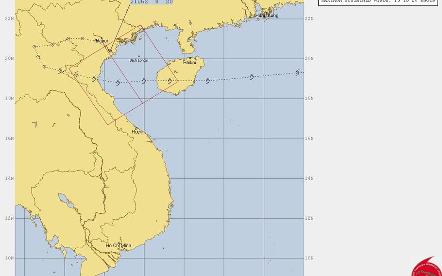
(Naval Meteorology & Oceanography Command )
3 p.m. Saturday, July 21, Vietnam time: Incredibly, after four days meandering over land, the remnants of Tropical Storm Son-tinh are emerging over water near the Gulf of Tonkin, 52 miles southeast of Hanoi. And according to the Joint Typhoon Warning Center, it could regenerate over the coming days. Stay tuned.11 p.m. Tuesday, July 17, Hong Kong time: Tropical Storm Son-tinh is moving rapidly west, out of the Hong Kong area, and remains on course to pass over northern Hainan island, then make landfall over northern Vietnam and die out south of Hanoi. Strong Wind Signal 3 remains raised for Hong Kong; expect the all-clear to be issued early Wednesday.
At 8 p.m., Son-tinh was 227 miles south-southwest of Hong Kong, moving west at 25 mph. Son-tinh has peaked at 46-mph sustained winds and 58-mph gusts, according to the Joint Typhoon Warning Center and should gradually diminish as it moves west, passing 130 miles south of Hanoi at 9 p.m. Wednesday.
11 a.m. Tuesday, July 17, Philippines time: Standby Signal 1 has been raised for Hong kong, mainly as a precaution. Son-tinh has been upgraded to a tropical storm by the Joint Typhoon Warning Center, is forecast to pass well south of Hong Kong and is accelerating away from the Philippines.
At 8 a.m., Son-tinh was 325 miles southeast of Hong Kong, moving west at 32 mph with 40-mph sustained winds and 52-mph gusts at center.
Tropical Storm Warning Signal 1 remains raised for the Babuyan islands and northern portion of Ilocos Norte, according to the Philippines national weather authority PAGASA; expect all signals to be lowered by Tuesday afternoon.
Chances of Hong Kong accelerating to Strong Wind Signal 3 didn't seem likely, according to the Hong Kong Observatory. For the moment, Signal 1 remains raised. Son-tinh is forecast to peak at 46-mph sustained winds and 58-mph gusts, but pass 190 miles south of Hong Kong at 6 p.m.
5 p.m. Monday, July 16, Philippines time: Tropical Depression 11W remains on course to skim north of the Philippines' island of Luzon, then the northern tip of Hainan Island before making landfall south of Hanoi late Wednesday, according to the Joint Typhoon Warning Center.
At 1 p.m., 11W was 351 miles northeast of Manila, headed west-southwest at 14 mph, with 35-mph sustained winds and 46-mph gusts. JTWC projects 11W to peak at 52-mph sustained winds and 63-mph gusts early Wednesday morning.
11W is forecast to head west-northwest Monday evening, pass 267 miles north of the old Clark Air Base at midnight Monday, then 196 miles south of Hong Kong as evening falls on Tuesday.
It's then due to cross the northern edges of China's Hainan Island, then make landfall Wednesday evening, passing 70 miles south of Hanoi around midnight.
Tropical Storm Warning Signal 1 remains raised for the Batanes and Babuyan islands and the northern portions of Apayao, Cagayan and Ilocos Norte, according to the national weather authority PAGASA.
12:45 a.m. Monday, July 16, Philippines time: A new tropical depression has formed northeast of the Philippines’ northernmost main island of Luzon. It’s forecast by the Joint Typhoon Warning Center to pass over the Batanes and Babuyan islands between Luzon and Taiwan, heading west over the northern tip of Hainan, then making landfall northeast of Hanoi.
At 8 p.m., 11W was 562 miles northeast of Manila, headed west-southwest at 16 mph with 29-mph sustained winds and 40-mph gusts. 11W is forecast by JTWC to pass 288 miles north of the old Clark Air Base at midnight Monday, peak at 58-mph sustained winds by mid-evening Wednesday, then come ashore early Friday evening, dying out as it passes 47 miles northeast of Hanoi at 8 p.m. Friday.
11W has been designated a tropical depression named Henry by the Philippines national weather authority PAGASA. Tropical Cyclone Warning Signal 1 has been issued for the Batanes and Babuyan island groups and the northern portions of Cagayan, Apayao and Ilocos Norte.
2:15 p.m. Saturday, July 14, Guam time: A tropical disturbance about 720 miles northwest of Guam is the subject of a tropical cyclone formation alert issued at noon by the Joint Typhoon Warning Center. The disturbance is forecast to head west, between Taiwan and the Philippines, and well south of Okinawa, with gradual development over the next couple of days.