Asia-Pacific
The day an underwater volcano almost wiped out a nation
By
The Washington Post September 2, 2023
Derek Hawkins, Charlotte Lytton, Matthew Abbott, Shelly Tan and Frank Hulley-Jones
The Washington Post September 2, 2023
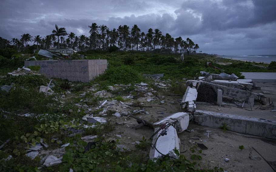
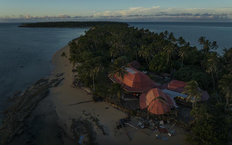
The Vakaloa Beach Resort, a tourist destination on Tonga's main island, was destroyed by the tsunami on Jan. 15, 2022. More than 18 months after the eruption, there is no sign of rebuilding at the property. (Matthew Abbott for The Washington Post)
First came the burnt-match smell of hot sulfur. Then, a roar from below the water.
The towering undersea volcano known as Hunga Tonga-Hunga Ha'apai had awakened, and on a balmy afternoon in January 2022 it began blasting its insides into the sky above this Pacific island chain with a force unmatched in recent history.
People thousands of miles away heard the explosions. The plume of ash and gas blotted out the sun. Tsunamis hurtled outward, engulfing villages in Tonga's low-lying islands and crashing into shorelines as far away as Peru.
It was one of the most powerful volcanic eruptions ever recorded. And it was a wake-up call.
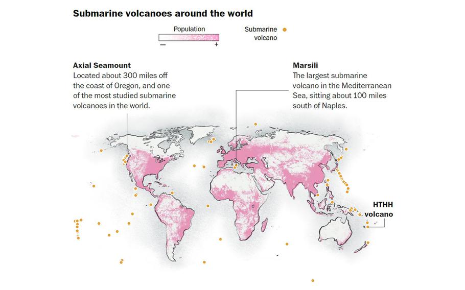
Scientists say the event underscored the dangers posed by submarine volcanoes, which are found by the thousands in every ocean on Earth, some of them perilously close to coastlines.
But more than 18 months after the historic eruption, even the most vulnerable nations are struggling to keep closer watch over these underwater behemoths.
Experts estimate there are dozens of active seamounts around the globe that could, under the right circumstances, erupt like Hunga, with the potential to claim hundreds of thousands of lives and reshape coastlines. Roughly a million other submarine volcanoes exist globally, most of them millions of years old and extinct.
These are some of the world's least-monitored natural hazards. Only a handful of the most accessible submarine volcanoes have ever been mapped in detail. Even veteran volcanologists say they know little about what goes on inside these magma-filled structures between eruptions.
The challenge in studying them involves both cost and logistics. The specialized equipment used for monitoring is expensive - often too much of a financial burden for well-heeled research institutions, let alone small developing nations such as Tonga. Many of these volcanoes span long stretches of the ocean. Deploying the instruments is arduous, even in shallow waters, requiring skilled crews and a network of vessels and communication devices to provide real-time data.
"It is difficult to say which one will be next," said Kenna Harmony Rubin, a professor of geochemistry and volcanology at the University of Hawaii, "and when."
(Washington Post)
Hunga Tonga-Hunga Ha'apai formed in early 2015 after a moderate volcanic eruption fused two uninhabited islands into a single landmass. The volcanic cone was visible above the waves.
The volcano extends about 6,500 feet down to the ocean floor.
Its caldera, the craterlike depression at the summit, dipped roughly 500 feet below sea level prior to the 2022 eruption.
Like other volcanoes, Hunga's interior contains vents and magma reservoirs that make up a volcanic plumbing system extending deep into the rock.
As the magma churns through this system, gases can build up, increasing the pressure inside. Eruptions can happen when the internal pressure becomes too strong for the rock to hold back.
'An impending doom'
Volcanic activity is a fact of life in Tonga. Residents are well attuned to the risks posed by falling ash and ocean swells that can result from shallow-water eruptions - though nobody could have predicted the events of January 2022.
The kingdom, formerly a British protectorate, is made up of about 170 tiny, mostly flat islands, only about a quarter of which are inhabited. Scattered throughout the archipelago are 12 active underwater peaks, including Hunga. All are part of the Kermadec-Tonga subduction zone, where one tectonic plate dives beneath another. This seismically active region of the Pacific stretches from New Zealand's North Island to the northwestern tip of the Tonga island chain.
Most of the homes and buildings in Nomuka township that were close to the waterfront were destroyed by the tsunami. (Matthew Abbott for The Washington Post)
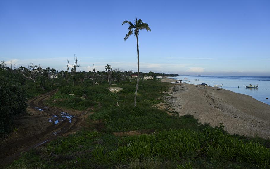
Most of the country's roughly 106,000 residents live on the main island of Tongatapu, a 100-square-mile atoll about the size of Sacramento. The economy is driven mainly by agriculture, along with tourism and fishing. Many Tongans rely on small plantation farming for a living, harvesting cash crops such as coconuts, squash and root vegetables. Many also depend on remittances sent from family members who work abroad.
Hunga had been mostly inactive for seven years when a series of small eruptions began in December 2021. An ash plume became visible from Tonga's capital city, Nukualofa, about 40 miles away on Tongatapu's north coast. Sulfur dioxide drifted across Tonga's other island groups, while bursts of steam and ash spilled over the volcano's edge.
On Tongatapu, people would sometimes gather for drinks and watch the volcano bubble. Virginie Dourlet, a French teacher who until recently lived in Nukualofa, said she remembers wondering, "Is the baby island going to survive?"
By early January 2022, the activity seemed to have subsided. The Tonga Geological Services declared the volcano dormant on Jan. 11.
But a few days later, the sulfuric odor wafted over the Tongan capital. The sky turned an otherworldly blue and purple, the result of fine ash particles scattering the sun's light. "It was gorgeous," Dourlet said, "but in an impending doom kind of way."
Soon, the water along the Nukualofa waterfront began to retreat, creating whirlpools. Locals instantly recognized this as a sign of a coming tsunami.
"People completely freaked out," Dourlet said.
Sela Faitangane holds her daughter Nunia outside Nomuka's only hospital, which was destroyed by the tsunami. (Matthew Abbott for The Washington Post)
Sela Faitangane, a 30-year-old teacher and mother of two, was walking through a wooded part of Tonga's Nomuka island when she heard a thunderous boom. The ground beneath her shook.
She emerged from the tree line and saw friends and neighbors running inland. People were shouting frantically, some of them carrying children in their arms. Ocean water was rushing over the landscape.
A boy called out to her, "You can't go there!"
"He meant you can't go near the road," Faitangane recalled, "because it was already flooded with the sea."
Faitangane scrambled into her car with her husband, her newborn baby and 4-year-old son, and headed for high ground. More booms came, so loud that they left a ringing in Faitangane's ears. Speeding away, they watched in terror as a wall of water inundated their neighborhood, toppling houses.
The sky darkened. Ash rained down. Faitangane and other Nomuka residents sheltered on a hillside. When they ran out of clean water for making baby formula, Faitangane had to hand her infant daughter to another mother to breastfeed.
"On that day," Faitangane said, "we thought it was the end of the world for us."
A global team of researchers led by Shane Cronin, of the University of Auckland, and the Tonga Geological Services spent months investigating what made the Hunga eruption so violent.
The Hunga eruption appears to have started with a mixing of different types of magma inside the volcano, which may have caused a rapid buildup of gas, Cronin's team found.
The pressurization initiated the eruption and expelled molten rock with such force that it caused a downward collapse of the caldera.
The surrounding ocean rushed in over the hot molten rock rising through the structure.
Steam and magma blasted through the volcano's narrow fissures, while also tearing open new cracks and allowing more magma to froth upward.
The result was a chain reaction of explosions as the water drained into the volcano and encountered fresh magma. Volcanic material shot up at hypersonic speed, forming a plume that stretched 36 miles into the sky.
The eruption generated two types of tsunamis. One was most likely caused by the caldera collapse displacing a huge volume of seawater. The other may have been caused by atmospheric shock waves from the eruption.
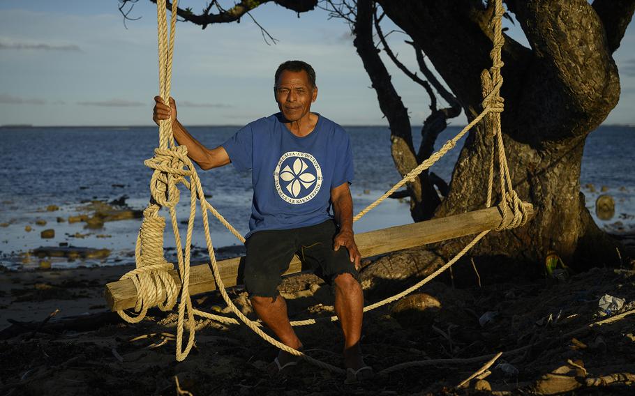
Lisala Folau sits near the mangrove tree he clung to for 27 hours to survive the tsunami. (Matthew Abbott for The Washington Post)
Tsunami waves - some of them topping 50 feet - crashed into Tonga's islands within an hour of the eruption. Hours later, smaller waves reached other coastlines around the world.
Southwest, on the island of Atata, Lisala Folau was out walking when the waves struck. He grabbed hold of a mangrove tree as the waters tossed his body. At one point, he could hear his son calling out to him, but he didn't answer because he didn't want his son to risk his life trying to rescue him.
Folau held on like that for 27 hours, he said, thinking the whole time, "I can't lose the tree."
On another part of the island, Elisiva Tu'ivai and her grandmother also clung to mangroves for hours as the sea rocked them. They struggled to keep their heads above water.
"I was scared I would die," Tu'ivai said, as "the water washed me in and out."
In the brief respite between wave swells, they managed to wade back to land. They clambered to the island's highest point, the path strewn with broken trees and rubble that had been her neighbors' homes.
As the night went on, other survivors emerged from the water. The next day, they caught a boat to Tongatapu, beginning what would be a nearly year-long period without homes of their own.
In total, the Hunga eruption spanned from the afternoon of Jan. 15 to the next morning. The shock wave propagated around the planet, felt more than 7,000 miles away in India.
The tsunamis ravaged Atata, as well as Tonga's smaller Mango Island, about 60 miles away. Four people died. Some 84 percent of the country's population was affected by the blast, either by being displaced or suffering damage to their properties and plantations.
Tonga went dark for days. Cables that supplied the island nation with phone and internet connectivity were severed. The volcanic plume was the biggest and highest ever viewed by satellite, rendering the country unobservable from the sky and leaving people around the world worried about the severity of the damage.
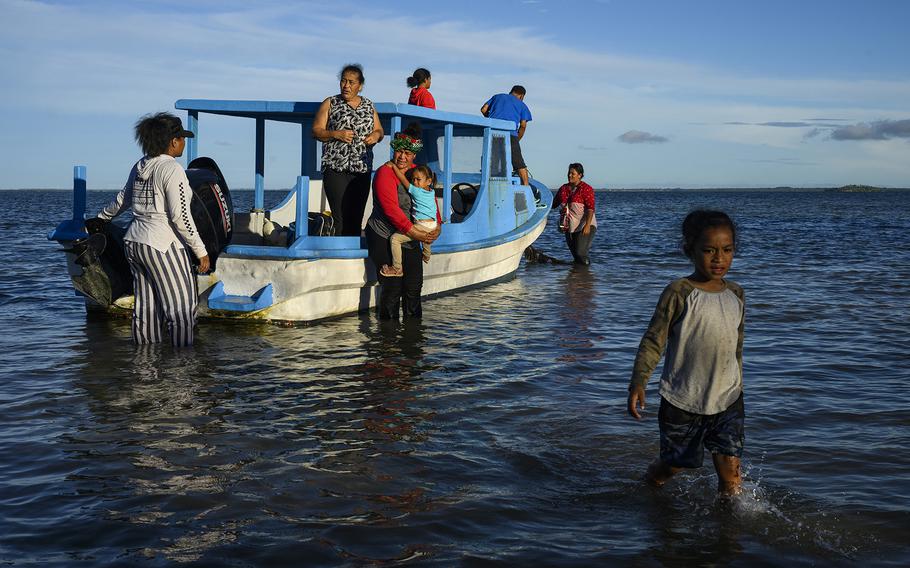
Lisala Folau and his family make their way to the shore of Atata island, where they used to live before the tsunami. (Matthew Abbott for The Washington Post )
Atata island was almost entirely submerged with seawater after the Hunga eruption. (Matthew Abbott for The Washington Post)
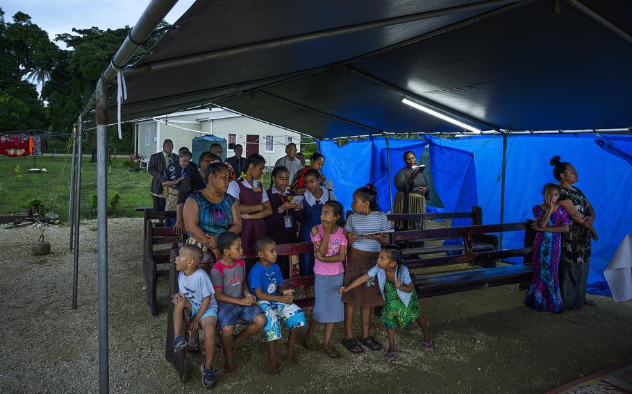
Displaced by the tsunami, former residents of Atata gather for a church service. (Matthew Abbott for The Washington Post)
"We couldn't see the impacts on the ground. Was the island just gone? Had the entire population died? Even when the ash cloud disappeared, we still didn't know because the undersea cables were severed," said volcanologist Sam Mitchell of the University of Bristol. "The satellite images were coming out and we still hadn't heard from them. It was traumatizing."
Faitangane spent a day on the hill on Nomuka with her family and others waiting for the waters to recede.
"When we came down, there was nothing left for us," she said. "Not even our house, our clothes, no food."
Rescue boats arrived and provided some relief, she said. The family initially lived in a tent, then moved into an old house that withstood the tsunami. "As long as we feel shelter over our head," she said, "that's okay with us."
'We will never forget'
The devastation in Tonga has renewed focus on the dangers of underwater volcanoes around the world and has sparked questions about which one might be next to blow. But experts caution that even comparatively wealthy nations will struggle to keep tabs on threats lurking offshore.
"The current state of monitoring is simply that almost none are monitored at all," said David Clague, a volcanologist at the Monterey Bay Aquarium Research Institute in California. "This lack of monitoring is not neglect, but simply that there are many such potentially active submarine volcanoes, and even a single seismometer is expensive to install and to maintain."
The Western Pacific is now the prime area of concern, said Bill Chadwick, a research professor at Oregon State University's Hatfield Marine Science Center. Explosive activity is common in subduction zones. A 1,740-mile stretch starting near Japan and extending south in the Western Pacific is a particular danger point. The same is true for the subduction zone that links Samoa, Fiji and Tonga, as well as for the one near the Aleutian Islands, a chain of large volcanic islands in Alaska that are geologically similar to Hunga.
Some of the known submarine volcanoes could pose a significant hazard to nearby populations. Marsili, a 1.8-mile-tall volcano beneath the Tyrrhenian Sea, sits a mere 109 miles south of Naples. Recent models have shown that activity there could trigger a tsunami with potential waves of almost 100 feet, swallowing the Sicilian and Calabrian coasts.
The challenge is that "submarine volcano monitoring is in its nascency," said Rubin, of the University of Hawaii, "well behind the state-of-the-art for volcanoes on land."
Scientists must constantly monitor for rapid changes at the surface that can indicate accumulation of magma below, as well as the buildup of toxic gases and increased seismic shaking that can indicate an increase in pressure.
Real-time monitoring requires telecommunications between instruments deployed on the seafloor and a laboratory, with either a cable connecting the instrument to the lab, or a buoy wired to a device capable of transmitting acoustic data via satellite. Research operations to volcanic sites can cost an estimated $36,000 per day, while installing cables nearby to pick up activity runs into the millions.
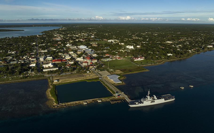
A view of Nukualofa, Tonga's central hub of political and economic activity. In 2022, the French Navy patrol vessel La Glorieuse brought aid to the island in the aftermath of the eruption. (Matthew Abbott for The Washington Post)
"For the several hundred known submarine volcanoes, such a network is simply too expensive to contemplate," Clague said.
In the long term, Rubin says more affordable solutions for monitoring submarine volcanoes may be on the horizon, such as swarms of inexpensive next-generation sensors that could collectively send data back to shore for computers to analyze.
"We aren't there yet as a global scientific community," Rubin said, "but hopefully the next decade of technology advances allow this to occur."
On Tonga, last year's epic blast has heightened the urgency of all kinds of volcanic monitoring, and geologists are now working to install new instruments to monitor the land-based volcanoes along the main island chain.
Thermal infrared detectors will help experts watch for temperature changes at vents and fissures that can signal eruptive activity. Sulfur gas monitors will track the release of dangerous volcanic fumes. Tonga is also being outfitted with synthetic aperture radar, which scientists can use to identify whether there have been changes such as ground swelling due to magma rising closer to the surface.
Half of eight planned new seismographs are currently running, though Cronin, of the University of Auckland, noted there is a "lack of long-term seismic records in the area to provide a background of what is normal and what is heightened activity."
"Volcano monitoring for eruption prediction in general is a difficult business," Rubin said. Even with lots of monitoring equipment installed, sometimes warnings come just days or even hours before a blast. And advanced warning can't always prevent the long-term repercussions of a major eruption.
In the aftermath of the Hunga eruption, Tu'ivai's family had to relocate to the kingdom's main island. Ten of them now live together in Masilamea, in one of 22 units on a newly built plot funded by the government. That includes her mother, Elisiva Taimikovi. Their jobs at a local resort were wiped away, too, leaving the family unsure what the future holds.
"We have only been given the houses. This is not a home. Our plantation and routines have gone," Taimikovi said. The unit is sparse; the family sits cross-legged on the floor, a small tent outside their front door where much-needed extra rooms should be.
"We knew we couldn't rebuild" what was lost last year, she said. But this new reality is hard to accept. "We'll never forget. This will stay with us forever."
Lytton and Abbott reported from Tonga. Additional contributions by Sam Mitchell of the University of Bristol; Shane Cronin of the University of Auckland; David Clague of the Monterey Bay Aquarium Research Institute in California; Frank Ramos of New Mexico State University.