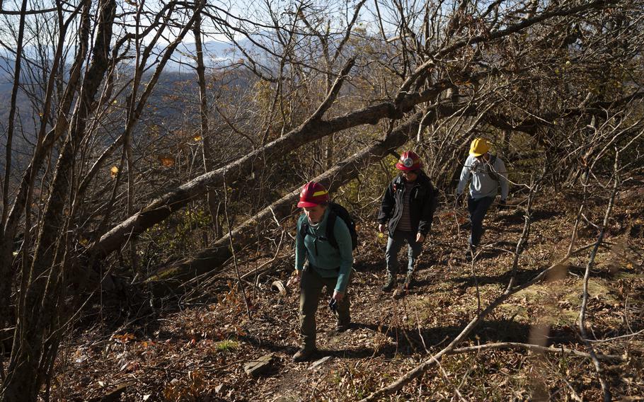
From left, Anne Sentz, Emily Powell and Franklin Tate, with the Appalachian Trail Conservancy, check out a portion of the famed trail in the wake of Hurricane Helene’s destruction. (Allison Joyce/For The Washington Post)
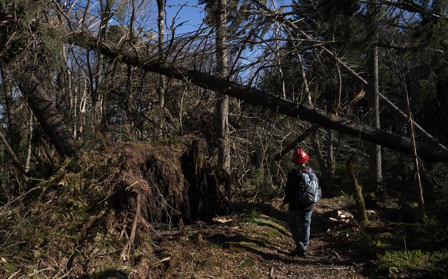
UNAKA MOUNTAIN, Tenn. — On a mountaintop mantled in moss and nearly century-old red spruce, the Appalachian Trail now simply disappears.
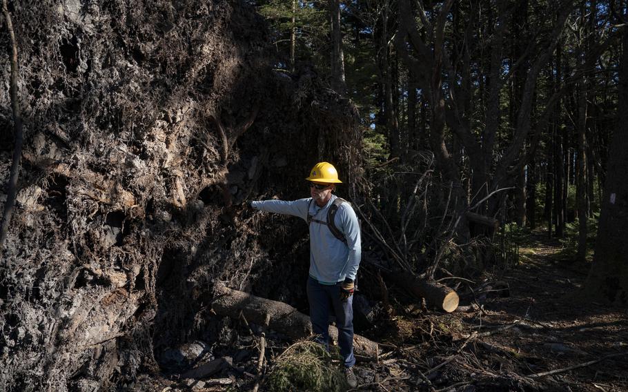
For lengthy stretches, it lies under tangles of trees that brutal winds from Hurricane Helene toppled last month. In one spot, a waist-high root ball blocks part of the path. Getting past it means climbing up and stepping along the spongy surface of still another root ball.
“You don’t have to be an ecologist or a thru-hiker to know this area is special. To see this much destruction is chaotic and scary,” said Emily Powell, a coordinator for the Appalachian Trail Conservancy.
Such ruin in this once-magnificent cloak of red spruce, already an imperiled ecosystem at the top of 5,180-foot Unaka Mountain, is a small part of the havoc that Helene wrought along hundreds of miles of the beloved trail through North Carolina, Tennessee and parts of southwest Virginia.
Nothing in the A.T.’s history compares with the scope and complexity of the damage. The conservancy initially shut down more than 800 miles from Georgia to the southern border of Shenandoah National Park in Virginia. That was more than a third of the world’s longest hiking trail, suddenly littered with craters from those uplifted root balls, with switchbacks erased by mudslides.
The closures, guided by U.S. Forest Service safety concerns, came at a cost.
“People need these places for their mental health,” said Anne Sentz, a regional manager with the conservancy in southern Appalachia. “It breaks my heart knowing that people can’t do that safely right now when it’s so desperately needed in these times.”
Both Sentz and Powell were on the mountain in mid-October to help assess conditions on behalf of the Forest Service. In a full day, they covered 3½ miles, logging observations and photos with GPS coordinates into a special app while navigating terrain covered by as much as 5 inches of snow. They eventually had to turn around because they reached a spot where fallen trees stacked on top of one another made the trail impassable.

Emily Powell, with the Appalachian Trail Conservancy, surveys downed trees that have made portions of the Appalachian Trail impassable in Tennessee and North Carolina. “To see this much destruction is chaotic and scary,” Powell says. (Allison Joyce/For The Washington Post)
Officially, that section and the rest of the trail in Tennessee’s Cherokee National Forest have been reopened. Areas through Pisgah National Forest in North Carolina remain closed and are marked on a conservancy map with a bright red box.
“Just because an area is open does not mean it is safe,” the group’s website cautions, noting a “high risk of landslides” as well as washed-out bridges and swollen creeks.
Because the wreckage is so scattered, assessors will have to hike every foot of the trail. That task alone could take months.
The repairs are expected to be extraordinarily expensive, with the conservancy already trying to raise private money to supplement public funds. The effort also will require substantial expertise.
The Carolina Mountain Club and the Tennessee Eastman Hiking & Canoeing Club, whose volunteers maintain the Appalachian Trail in the national forests north of the Smokies, have started some of the easier work. Yet cutting through the tens of thousands of trees that lie across the trail in isolated spots will take expert sawyers, Sentz said.
“The wind came through and just knocked the trees down like toothpicks,” she said on a return visit last week. “There’s pockets of that across 400 miles.”
Despite the devastation, officials hope the annual thru-hiking season — in which folks start at Springer Mountain in Georgia with the goal of traversing the 2,198 miles to Mount Katahdin in Maine — will be possible in 2025. Northbound backpackers generally begin in March or April.
The trail is nicknamed “the Green Tunnel” because of the dense tree canopy and archways of rhododendron in several states. North of Great Smokies National Park, Forest Service crews and volunteers have found a shredded canopy that is allowing birds to drop seeds and berries from invasive species onto the forest floor.
“It’s going to take forever for some of the areas to reforest,” said Franklin Tate, an associate regional director at the conservancy, which will mark its centennial in 2025.

Franklin Tate, who works for the Appalachian Trail Conservancy, predicts that some areas through southern Appalachia will take decades to reforest. (Allison Joyce/For The Washington Post)
Thru-hikers will need to be flexible and patient next year. The trail is “going to contain numerous detours that will cause the hikers to exercise more patience than usual and possibly spend a little more time on human-made surfaces,” Tate said.
And the small towns that backpackers rely on for resupplies and hostel visits will continue to face their own challenges. Hot Springs, N.C. and Erwin, Tenn., to name two, are recovering from damaged water-delivery and communications systems, plus the loss of bridges, roads, significant portions of their commercial districts — and lives.
Chris Donochod is looking ahead with his Big Pillow Brewing, which flooded when the waters rose in Hot Springs. He hopes to reopen in December and have his taproom in full swing by spring, when he typically sees the most thru-hikers pausing for a meal while they resupply food or switch out gear. They represent an important part of his businesses.
Hot Springs “will be somewhat ready for hikers,” Donochod said Thursday. He added a caveat, though: “I’m really not sure what the town will look like at that point.”
It all will make for a far different experience, one that may affect people in lasting ways.
Nick Obradovich, a chief scientist at the Laureate Institute for Brain Research in Tulsa, investigates the link between climate change and mental health. Visual evidence of a violent storm can strip away the beauty and solace many find in wilderness, he said.
“If you like the Appalachian Trail the way that it was, and it gets devastated, you’re going to be reminded of the disaster,” he said. “And that’s an impact of the disaster that can last for a decade-plus.”
Kristin Brewer, 31, of Little Rock, intends to start off from Springer Mountain in late March. She understands the need for flexibility, to skip damaged sections on her trek north and maybe return when they are ready. Brewer maintained trails in Utah as an AmeriCorps volunteer in 2015.
“I am keenly aware of all the work it takes to get trails back,” she said.
Among the 3 million people who hike the A.T. every year is retired Army colonel Bill Mulvey, 78. He discovered it in 1968 while training to be an Army Ranger in the north Georgia mountains. For a decade, he has spent a few weeks each spring on the trail.
It feels like an old friend to Mulvey, who splits his time between Griffin, Ga., and Bonaire, an island off the Venezuelan coast.
“I look forward to seeing this person every year,” he said in the wake of the hurricane. “If for some reason it was denied to me. I don’t know what I’d do. I’d be lost.”