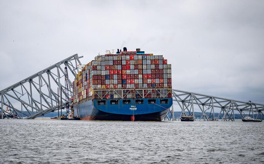
The container ship Dali is seen in the wreckage of Francis Scott Key Bridge on Apr 1, 2024, almost a week after it hit a structural pier causing a subsequent bridge collapse in Baltimore. (Jerry Jackson/Baltimore Sun/TNS)
BALTIMORE (Tribune News Service) — The first images of the Francis Scott Key Bridge’s mangled position at the bottom of the Patapsco River were taken using sonar technology.
The underwater images, released Wednesday, came from the Navy’s Coda Octopus, a sonar 3D imaging device that captures what conventional cameras can’t in murky water.
The Navy has joined the scores of local, state and federal agencies racing to clear bridge wreckage that blocks entry into the Port of Baltimore and eventually remove the cargo ship that rammed into it, killing six people. It’s a dangerous clean-up job for divers who, before Wednesday, could only navigate by touch.
The addition of the Coda Octopus represents a “new level of access and a new level of vision to move the mission forward,” Gov. Wes Moore said at a news conference showcasing the images. The surveying tool helps divers working in darkness determine if and how the wreckage is connected. That information guides how to best rig and remove pieces of the crumpled bridge from the 50-foot-deep channel.
The wreckage is then placed on a barge. The Navy sent three barges: A 1,000-ton lift-capacity derrick barge, called the Chesapeake, a 200-ton lift-capacity crane barge, called the Ferrell, and a 150-ton capacity crane barge, called the Oyster Bay. A fourth barge with a 400-ton capacity is on its way. The barges were contracted through the Naval Sea Systems Command.
About 135 Navy personnel, two utility boats and a ridged hull inflatable boat have come to Baltimore since March 26, the day the bridge collapsed. Tugboats and 12 crane and support vessels will arrive in the next few days.
Capt. Sal Suarez, the Navy’s supervisor of salvage and diving, is leading a team of 20 on an emergency contract. No active-duty Navy divers are part of the salvage efforts. The divers assess any damage to the Dali, a 984-foot cargo ship, and pinpoint where it grounded.
Supervisors on land who direct divers in the water can get a situational awareness of the wreckage thanks to the Coda Octopus’ sonar and lidar system, Suarez said at a Thursday news conference.
Army Corps of Engineers set a tentative and “ambitious” timeline to clear and restore access to the Port of Baltimore by the end of May, they said in a statement Thursday. Engineers plan to open a smaller, 280-foot-wide and 35-foot-deep channel by the end of April for barge container service and some vessels that move automobiles and farm equipment.
Moore showed a video Thursday from a diver’s point of view in the grey and dark water, describing it as similar to driving in a snowstorm with high beams on.
“Despite the Coda footage that we’re using … it still takes time,” Suarez said in a video Thursday. “You’re limited by how much time you can spend on the bottom depending on the depth for each diver. You’re also limited by the safety factor. This is wreckage in all sort of shapes and sizes and it’s dangerous.”
For wreckage that can’t be individually rigged, the Navy called for a salvage bucket to be transported from Galveston, Texas. The bucket, included in the Navy’s emergency salvage contract, acts as a “giant grab” that lifts wreckage out of the water, Suarez said at a news conference.
Six men are presumed dead after the bridge collapsed while they were filling potholes on the road. The bodies of two men were found the next day in a pickup truck in the river, while four are still missing.
Navy-contracted divers are leading the salvage effort while Maryland State Police divers are “standing by to assist with the recovery operation as soon as it is safe to do so,” Maryland officials part of the Key Bridge Response Unified Command said in a news release Thursday.
The Navy is part of the Key Bridge Response Unified Command, along with the Coast Guard, Army Corps of Engineers, Maryland Department of Environment, Maryland Transportation Authority, Maryland State Police, and other agencies.
©2024 Baltimore Sun. Visit baltimoresun.com. Distributed by Tribune Content Agency, LLC.